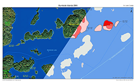
Burntside Islands SNA
About • Location • Activities • Ecology
About |
||
Ownership |
||
|
||
Links |
||
Overview |
||
|
||
History |
||
|
||
Management |
||
|
||
Comments |
||
|
||
Driving Directions |
 |
|||||
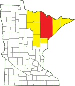
| St. Louis County | ||||||
| Northeast Minnesota | ||||||
Activities |
||
Hiking Trails |
||
No maintained trails |
||
Hunting |
||
No hunting |
||
Ecology |
|||||||
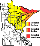
Ecological Classification |
 |
||||||
| Ecological Province | Laurentian Mixed Forest Province |
||||||
| Ecological Section | Northern Superior Uplands |
||||||
| Ecological Subsection | Border Lakes |
||||||
| Land Type Association | Trout Lake Bedrock Complex |
||||||
Native Plant Communities* |
|||||||
Aspen - Birch Forest, Balsam Fir Subtype Aspen - Fir Forest Lowland White Cedar Forest (Northern) Upland White Cedar Forest White Pine - Red Pine Forest |
|||||||
| * Source: The Minnesota Biological Survey, Minnesota Department of Natural Resources, Division of Ecological Resources | |||||||
Natural Features |
|||||||
|
|||||||
Boat Required
Burntside Islands SNA is accessible only by boat.

Visitor Photos |
|||||
Share your photo of this destination. |
|||||
| This button not working for you? Simply email us at info@MinnesotaSeasons.com. Attach one or more photos and, if you like, a caption. |
|||||
|
|||||
MinnesotaSeasons.com Photos |
|||||
|
|||||

Slideshows |
||
Visitor Videos |
|||
Share your video of this destination. |
|||
| This button not working for you? Simply email us at info@MinnesotaSeasons.com. Attach a video, a YouTube link, or a cloud storage link. |
|||
Other Videos |
|||
| Burntside Islands Scientific and Natural Area Virtual Hike Minnesota Department of Natural Resources |
|||
About
Apr 22, 2021 Burntside Islands SNA protects a chain of undeveloped, forested islands in the southwest part of Burntside Lake near Ely, Minnesota. The SNA islands complement the scenic beauty of this popular recreational lake, while protecting wildlife habitat and natural features of remarkable ecological value. It also protects suitable nesting habitat for Minnesota's state bird, the Common Loon, which relies on areas of undeveloped shoreline on large lakes. mndnr.gov/snas/sna01049 |
|||

Visitor Sightings |
||||||||||||||||||||||||||||||||
Share your sightings or comments about of this destination. |
||||||||||||||||||||||||||||||||
| This button not working for you? Simply email us at info@MinnesotaSeasons.com. |
||||||||||||||||||||||||||||||||
MinnesotaSeasons.com Sightings |
||||||||||||||||||||||||||||||||
|
||||||||||||||||||||||||||||||||
Plants |
||||||||||||||||||||||||||||||||
Plants frequently found in: Aspen - Birch Forest, Balsam Fir Subtype FDn43b1 Lowland White Cedar Forest (Northern) WFn53b |
||||||||||||||||||||||||||||||||
Created: Last Updated: © MinnesotaSeasons.com. All rights reserved. |
