Minnesota Destinations
Nature Destinations
These are locations in Minnesota where native plants, birds, and other wildlife can be viewed. With very few exceptions, these destinations are open to the public.
Each destination page includes driving directions, photos, and lists of plants and wildlife found on the site. Many include a printable map with GPS coordinates. Many also include videos.
More than 400 printable maps show GPS coordinates of site boundaries, trails, streams, and significant landmarks. Most also include a map of native plant communities.
Visitors can share their own photos, videos, plant and wildlife sightings, and other observations.
Snow Depth
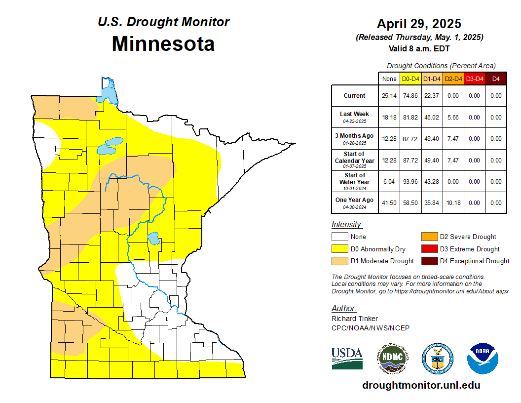
Drought Monitor
Recent Additions

Apple Blossom Overlook Park is a Winona County park located three miles north of downtown La Crescent, MN on Apple Blossom Drive Scenic Byway. Its 55 acres includes a ridge top overlooking the Upper Mississippi River Valley 580 feet below. A 1.3 mile loop trail has a spur that leads to a spectacular overlook on a narrow promontory. The trail is wide, grassy, and well maintained. It passes through new and old growth hardwood forest, two newly established prairies, and a few small areas of remnant prairie, and by rock outcroppings, steep cliffs, and an historic stone quarry. The park also includes a small depression that is sometimes a small pond but at other times just a wetland.

Vetsch Park is the second largest park in La Crescent Minnesota. At one time the location was an apple orchard. The owner donated the 25 acres to the City of La Crescent, and the park is named after him.
There is a parking area at the end of N. 2nd St. A short mowed trail leads west from the parking area, past a dog walking area, to a 0.52-mile loop trail. The loop trail passes through a red oak - white oak - silver maple forest as it climbs a steep bluff, follows a ridge line, and returns to the parking area.
There are also several other intersecting trails within and south of the park. One of these trails leads to Stoney Point, a bald area with a spectacular view of La Crescent and the Mississippi River. The narrow ridge and steep bluff is characteristic of the topography of the driftless area in southeastern Minnesota and western Wisconsin.

Tony Schmidt Regional Park is a Ramsey County park located in Arden Hills, stretching from County Road E and Lake Johanna Boulevard along the north shore of Lake Johanna to Mounds View High School and the 35W-694 cloverleaf interchange. It is largely a series of wetlands connected by streams and open bodies of water, nestled in among woodsy residential neighborhoods and other city parks, like Charles Perry Park and Chatham Open Area. The park is basically in three sections – an active railway cuts across the southern portion, and County Road E2 cuts across the north portion.
There are picnic grounds and shelters, playgrounds, a play field with backstop (Perry Park has three ball diamonds), and a boat launch, swimming beach, and fishing pier on Lake Johanna. A paved walking trail heads north from the main parking area, going through a tunnel under the railway and leading to an at-grade crossing at County Road E2. There are also several turf/dirt trails that lead off at different points; one trail leads over to Snelling Avenue and Lake Valentine. The campuses of two universities can be seen from the park: Bethel University across Lake Valentine, and the University of Northwestern-St Paul across Lake Johanna. A 2011 article by Jessica Bakeman in the Star Tribune also describes how residents around Lake Johanna take great care to keep the lake clean and free of invasive species like Eurasian milfoil (http://strib.mn/17kn2Zj). Near the beginning of the paved trail, a signpost talks about how a segment of the Arden Hills trail system was dedicated to the memory of former Governor Elmer L. Andersen. All in all, it is a well-maintained park, offering something for all comers.
— Kirk Nelson

Representative Bruce Vento was well-known as a champion for environmental causes in Minnesota and across the nation. During his tenure in Congress, he was chairman of the Subcommittee on National Parks, Forests, and Public Lands for ten years, overseeing the enactment of 300 laws. After his death in 2000, several places in the Metro area were established in his honor: the Vento View Overlook near Cherokee Park, the Bruce Vento Regional Trail in Maplewood and St. Paul, which then leads down through Swede Hollow to the Bruce Vento Nature Sanctuary.
The 27-acre sanctuary is located just east of downtown St. Paul, tucked in between the railroad tracks along Warner Road and the bluffs below Mounds Park. One cave, called Wakan Tipi (Spirit House), was a significant site for the Native Americans living in the area. In 1853, the North Star Brewery was built here, and they used one of the caves to store beer. Starting in the 1880’s, the area became a railroad and industrial area, later becoming largely abandoned in the 1970’s. In 2001, a coalition of St. Paul residents, neighborhood groups, and the City of St. Paul started work on purchasing the land, and in 2005 it became an official park open to the public. There is an ongoing effort to restore the land’s ecology and native plant communities, though reminders of the industrial history have been left in place. The sanctuary has also become a significant location for birdwatching and for educational opportunities.
— Kirk Nelson

Brownsville Bluff Scientific and Natural Area, in Houston County, was designated on January 19, 2016, to protect habitat for the milk snake and the state threatened western ratsnake. Neither snake is poisonous. The site consists of 286 acres bedrock bluff covered with windblown sediment. The 39-acre south section is a wildlife sanctuary that is closed to the public. The eastern-facing slopes are moderately steep to very steep. They have a mature, moderately moist forest of sugar maple, basswood, ironwood, northern red oak, and white oak.
The west-facing slopes are less steep. They have a dry to moderately moist mature forest of bur oak, northern pin oak, northern red oak, and paper birch, with some shagbark hickory, white oak, and black walnut. At the top of the bluff there is a prairie that has been used as an agricultural field. It will be restored to prairie and savanna.
An access road leads from the parking area (walk around the gate) 0.67 miles to the top of the bluff. A footpath follows the cleared fields on the bluff top to the northern boundary. Another footpath leads east from there to a spectacular overlook at the northeast corner of the SNA, a dizzying 400 feet above the road below.
Other Recent Additions

Norman County Section
Photo by Dan W. Andree
Superior Hiking Trail, Kadunce River State Wayside to Judge C.R. Magney State Park
| A | ||
|---|---|---|
Above the Falls Regional Park Audubon Center of the North Woods |

Photo by Dan W. Andree 
|
| B | ||
|---|---|---|
Badoura Jack Pine Woodland SNA Bald Eagle-Otter Lakes Regional Park Battle Creek-Indian Mounds Regional Park Battle Creek Regional Park Beaver Creek Valley State Park Belwin Conservancy Bertram Chain of Lakes Regional Park Big Marine Park Reserve Blazing Star Prairie Addition Preserve, North Unit Blazing Star Prairie Addition Preserve, South Unit Bluestem Prairie Addition Preserve Boulder Lake Environmental Learning Center Brackett Field Park, Minneapolis Bredesen Park, Edina Bruce Hitman Heron Rookery SNA Bruce Vento Regional Trail |

Photo by Wayne Rasmussen 


Photo by Kirk Nelson |
| C | ||
|---|---|---|
Caldwell Brook Cedar Swamp SNA Cannon River Turtle Preserve SNA Cannon Valley Trail Carlos Avery WMA, Carlos Avery Unit Carlos Avery WMA, Sunrise Unit Carpenter St. Croix Valley Nature Center Carver Highlands WMA, Middle Unit Carver Highlands WMA, North Unit Carver Highlands WMA, South Unit Cedar Creek Ecosystem Science Reserve Cedar Lake Farm Regional Park Central Mississippi Riverfront Regional Park Charles A. Lindbergh State Park Clifton E. French Regional Park Clinton Falls Dwarf Trout Lily SNA Coon Rapids Dam Regional Park Cupido WMA |


|
| D | ||
|---|---|---|
|
Day Park and Earley Lake Trail Dinner Creek SNA |

|
| E | ||
|---|---|---|
Eagle Bluff Environmental Learning Center |

|
| F | ||
|---|---|---|
|
Felton Prairie SNA, Assiniboia Skipper Unit Felton Prairie SNA, Bicentennial Unit Felton Prairie SNA, Shrike Unit Fish Lake Regional Park |


|
| G | ||
|---|---|---|
Garden Island State Recreation Area George H. Crosby Manitou State Park |


|
| H | ||
|---|---|---|
|
Hardscrabble Woods / MG Tusler Sanctuary Harry W. Cater Homestead Prairie SNA Hidden Falls-Crosby Farm Regional Park |


|
| I | ||
|---|---|---|

|
| J | ||
|---|---|---|
Jay C. Hormel Nature Center |

|
| K | ||
|---|---|---|
|
Kaplan’s Woods Parkway, Owatonna Kellogg Weaver Dunes SNA, Kellogg Weaver Unit |


|
| L | ||
|---|---|---|
|
La Salle Lake State Recreation Area Lac qui Parle WMA Lake Alexander Woods SNA, Central Unit Lake Alexander Woods SNA, North Unit Lake Alexander Woods SNA, South Unit Lake George Regional Park Lake Minnewashta Regional Park Lake Vermilion-Soudan Underground Mine State Park Lake Waconia Regional Park Lake Washington Regional Park & Campground Lake Wobegon Trail Laurentian Divide Recreation Area Lilydale-Harriet Island & Cherokee Heights Regional Park Lindgren-Traeger Bird Sanctuary Long Lake Regional Park |


|
| M | ||
|---|---|---|
|
Margherita Preserve-Audubon Prairie Martin-Island-Linwood Lakes Regional Park Marvin W. Schubring Memorial WMA Mary Schmidt Crawford Woods SNA Mesabi Trail Minneapolis Chain-of-Lakes Regional Park Minnesota Point Pine Forest SNA Minnesota Valley NWR, Black Dog Unit Minnesota Valley NWR, Blakeley Unit Minnesota Valley NWR, Bloomington Ferry Unit Minnesota Valley NWR, Chaska Unit Minnesota Valley NWR, Jessenland Unit Minnesota Valley NWR, Long Meadow Lake Unit Minnesota Valley NWR, Louisville Swamp Unit Minnesota Valley NWR, Rapids Lake Unit Minnesota Valley NWR, St. Lawrence Unit Minnesota Valley NWR, Wilkie Unit Minnesota Valley State Recreation Area, Lawrence Unit Mississippi Gateway Regional Park Mississippi Gorge Regional Park Mississippi National River & Recreation Area, Coldwater Spring Mississippi National River & Recreation Area, St. Anthony Falls Visitor Center Mississippi Oxbow SNA Mississippi West Regional Park Mound Spring Prairie SNA, North Unit |

Photo by Greg Watson


Photo by Kirk Nelson |
| N | ||
|---|---|---|
|
Nerstrand Big Woods State Park Nokomis-Hiawatha Regional Park North Black River Peatland SNA North Mississippi Regional Park Northern Tallgrass Prairie NWR, Bartells Unit Northern Tallgrass Prairie NWR, Bittbender Unit Northern Tallgrass Prairie NWR, Brandenburg Prairie Unit Northern Tallgrass Prairie NWR, Brenner Lake Unit Northern Tallgrass Prairie NWR, Cramlet Unit Northern Tallgrass Prairie NWR, Flickertail Prairie Unit Northern Tallgrass Prairie NWR, Forstrom Unit Northern Tallgrass Prairie NWR, Gislason Lake Unit Northern Tallgrass Prairie NWR, Green Muhly Unit Northern Tallgrass Prairie NWR, Harris Trust, et al. Unit Northern Tallgrass Prairie NWR, Hoffman Unit Northern Tallgrass Prairie NWR, Holland Braton Unit Northern Tallgrass Prairie NWR, Jessen Unit Northern Tallgrass Prairie NWR, Mears Unit Northern Tallgrass Prairie NWR, Pavia Unit Northern Tallgrass Prairie NWR, Pell Creek Unit Northern Tallgrass Prairie NWR, Rengstorf Unit Northern Tallgrass Prairie NWR, Spieker Unit Northern Tallgrass Prairie NWR, Storm Unit Northern Tallgrass Prairie NWR, Syverson Unit Northern Tallgrass Prairie NWR, Touch the Sky Prairie Unit Northern Tallgrass Prairie NWR, Woolcott Unit |


Photo by Kirk Nelson 
Hoffman Unit 
Touch the Sky Prairie Unit |
| O | ||
|---|---|---|
Ohuta Park, Lake City, MN |

|
| P | ||
|---|---|---|
P.N. and G.M. Nelson Wildlife Sanctuary Pankratz Memorial Prairie, North Unit Pankratz Memorial Prairie, South Unit Pembina Trail Preserve SNA, Crookston Prairie Unit Pembina Trail Preserve SNA, Foxboro Prairie Unit Pembina Trail Preserve SNA, Pembina Trail Unit Phalen-Keller Regional Park Pigs Eye Island Heron Rookery SNA Prairie Creek WMA, Engeseth-Rinde Unit Prairie Creek WMA, Koester Prairie Unit Purrington Prairie SNA |


|
| Q | ||
|---|---|---|
Quarry Hill Nature Center |

|
| R | ||
|---|---|---|
|
Red River State Recreation Area Reno North Recreational Area Rice Creek Chain of Lakes Park Reserve Richard M. & Mathilde Rice Elliot SNA Riverfront Park, Moorhead Robert Ney Memorial Park Reserve Rockwell WMA Root River Park Rum River Central Regional Park |


|
| S | ||
|---|---|---|
St. Croix Bluffs Regional Park Sand Lake / Seven Beavers Preserve Sand Prairie Wildlife Management and Environmental Skull Lake, North Tract Skull Lake, West Tract South Black River Peatland SNA Split Rock Lighthouse State Park Spring Beauty Northern Hardwoods SNA Stanley Eddy Memorial Park Reserve Straight River Wildflower Preserve |


|
| T | ||
|---|---|---|
|
Theodore Wirth Regional Park Two Inlets at Bde´ Heh?a´ka - Omashkooz Zaaga’igaans Regional Park |


|
| U | ||
|---|---|---|

|
| V | ||
|---|---|---|
Vadnais-Snail Lakes Regional Park Verlyn Marth Memorial Prairie SNA |

|
| W | ||
|---|---|---|
|
Weaver Dunes Addition West Rat Root River Peatland SNA White’s Woods County Park Whitewater WMA, Main Branch Unit Wood Park, Burnsville |


|
| X | ||
|---|---|---|
|
|
| Y | ||
|---|---|---|

|
| Z | ||
|---|---|---|

|