![]()
![]()
![]()
![]()
Fort Snelling State Park
About • Location • Activities • Ecology
About |
Ownership |
|
Links |
Overview |
|
History |
|
Management |
|
Comments |
|
Location |
||||||||||||||||||||||||||||||
Size |
||||||||||||||||||||||||||||||
3,711 acres statutory, 2,654 owned |
||||||||||||||||||||||||||||||
Driving Directions |
||||||||||||||||||||||||||||||
|
||||||||||||||||||||||||||||||
Parking |
||||||||||||||||||||||||||||||
101 Snelling Lake Road N44 52.414, W93 11.493 |
||||||||||||||||||||||||||||||
Hours |
||||||||||||||||||||||||||||||
Daily from 8 a.m. until 10 p.m. |
||||||||||||||||||||||||||||||
Fees |
||||||||||||||||||||||||||||||
Daily park permit: $7 Annual park permit: $35 |
||||||||||||||||||||||||||||||
Maps |
||||||||||||||||||||||||||||||

Activities |
||||||||||||||||
Hiking Biking Mountain biking Horseback riding Picnicking Camping Backpacking Rock climbing and bouldering Swimming Boating Canoeing Birding Nature photography Geocaching Cross country skiing Skate-skiing Winter hiking Snowshoeing Snowmobiling |
||||||||||||||||
Trails |
||||||||||||||||
|
||||||||||||||||
Hunting and Fishing |
||||||||||||||||
No hunting. The park may hold one or more managed hunts in the fall. In most cases, Minnesota residents do not need a permit to fish in Minnesota State Parks. |
Ecology |
|||||
Ecological Classification |
 |
||||
| Ecological Province | Eastern Broadleaf Forest Province |
||||
| Ecological Section | Minnesota & NE Iowa Morainal |
||||
| Ecological Subsection | Anoka Sand Plain St. Paul-Baldwin Plains and Moraines |
||||
| Land Type Association | Mississippi Sand Plain Pig’s Eye Alluvial Plain |
||||
Native Plant Communities* |
|||||
Bulrush Marsh (Northern) Calcareous Fen (Southeastern) Lowland Aspen Forest Mesic Oak Savanna (Southern) Red Oak - White Oak Forest Red Oak - White Oak - (Sugar Maple) Forest Silver Maple - (Virginia Creeper) Floodplain Forest Sugar Maple - Basswood - (Bitternut Hickory) Forest Willow - Dogwood Shrub Swamp |
|||||
| * Source: The Minnesota Biological Survey, Minnesota Department of Natural Resources, Division of Ecological Resources | |||||
Natural Features |
|||||
|
|||||
Popular Park
Fort Snelling State Park is the most visited state park in Minnesota.
Visitor Photos |
||
Share your photo of this destination. |
||
This button not working for you? |
||
Kirk Nelson |
||
| The Minnehaha Trail goes from the south end of Minnehaha Park to the visitors’ center in Fort Snelling State Park |  |
|
 |
 |
|
 |
 |
|
Marker by Mississippi River |
Marker on Pike Island |
|
Floods markers - one next to the Mississippi River, and one on Pike Island. From top to bottom: 1965, 1952, 2001, 1880 |
||
 |
 |
|
Minnesota River floodplain, just off the trail near Gun Club Lake |
Trail along the Minnesota River, south of Mendota Bridge to Gun Club Lake | |
 |
 |
|
Trail along the Minnesota River, south of Mendota Bridge to Gun Club Lake |
||
 |
 |
|
Run-off from Gun Club Lake that flows into the Minnesota River |
||
 |
 |
|
Trail along the Minnesota River, south of Mendota Bridge to Gun Club Lake |
||
 |
 |
|
Axel Von Bergen Trail, September 2015 |
||
Axel Von Bergen Trail, September 2015 |
||
 |
 |
|
Trails on Pike Island |
||
 |
||
Trails on Pike Island |
||
 |
 |
|
Visitor Center |
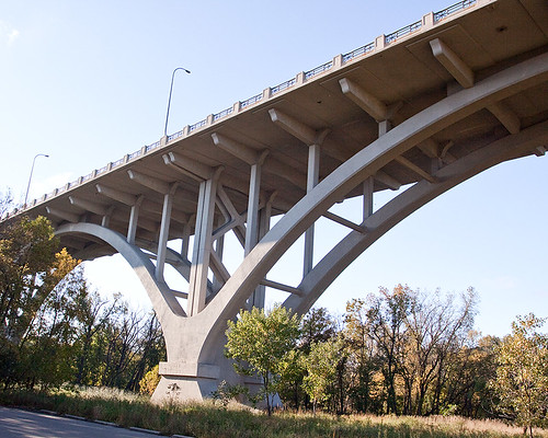
Mendota Bridge over Picnic Island |
|
|
 |
|
Beaver-gnawed Tree on Picnic Island |
||
Confluence of the Mississippi and Minnesota Rivers |
||
 |
 |
|
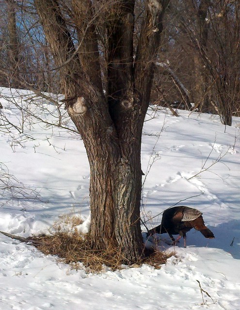
Turkeys and Deer at Fort Snelling State Park |
||

MinnesotaSeasons.com Photos |
||
 |
||
Park entrance |
||
 |
 |
|
Picnic Island |
||
 |
 |
|
Picnic Island |
||
 |
 |
|
The Point on Picnic Island |
||
 |
 |
|
The Point on Picnic Island |
Recent beaver activity | |
 |
 |
|
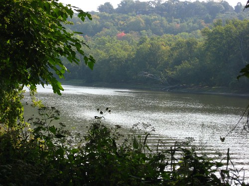
Minnesota River |
||
 |
 |
|
Minnesota River |
||

Slideshows |
Fort Snelling State Park |
|
About
Pictures taken from various walks at Fort Snelling State Park on the Mississippi and Minnesota rivers in Minneapols. |
Fort Snelling |
|
Fort Snelling Oak Woodland |
|
Fort Snelling State Park |
|
About
Fort Snelling State Park, MN |

Visitor Videos |
||
Share your video of this destination. |
||
This button not working for you? |
||
|
Other Videos |
||
North High Students Explore Fort Snelling State Park with Wilderness Inquiry & UWCA |
About
Published on Nov 14, 2013 Students from North High School in Minneapolis, MN had the opportunity to explore Fort Snelling State park as part of the Urban Wilderness Canoe Adventures (UWCA) program. They learned how to fish and canoe, and also learned about water quality testing, voyageur culture and history, and more with this innovative programming. This excellent footage was produced by iDream.tv and Minneapolis Public Schools. |
Fort Snelling State Park Hike |
About
Uploaded on Nov 11, 2006 I hiked the undulating trails of the Fort Snelling State Park today with my ubiquitous camera and the trusty Garmin eTrex. Hey, I'm back home, isn't that a miracle? |
Fort Snelling State Park ride |
About
Uploaded on Dec 3, 2009 Right in the middle of the Minneapolis/Saint Paul metro area is a state park at the confluence of the Mississippi and Minnesota rivers. The song is "Girl shaped love drug" by Southport's own Gomez. |

Visitor Sightings |
|
Share your sightings or comments about of this destination. |
|
This button not working for you? |
|
Chris Kurtz |
||
Plants |
||
| Canada moonseed (Menispermum canadense) |  |
|
Kirk Nelson |
||
Birds |
||
|
Great Blue Heron (Ardea herodias) |
 |
|
Fungi |
||
Chicken of the Woods (Laetiporus sulphureus) Crown-tipped Coral (Artomyces pyxidatus) Elm Oyster (Hypsizygus ulmarius) |
 |
|
Insects and Arachnids |
||
blue-fronted dancer (Argia apicalis) |
 |
|
Mammals |
||
| White-tailed Deer (Odocoileus virginianus) |  |
|
_05.jpg "blue vervain")

Reptiles |
||
| Common Snapping Turtle (Chelydra serpentina) |  |
|
Christa Rittberg |
||
Mammals |
||
 |
||
MinnesotaSeasons.com Sightings |
Visits |
3/5/2000 1/29/2014 |
Amphibians |
||||||||
|
||||||||


Fishes |
||
Fungi and Lichens |
||
Insects and Arachnids |
||||||||
|
||||||||
 |
||||||||
Mammals |
||
American Beaver (Castor canadensis) |
 |
|
Plants |
||||||||||
|
||||||||||
Minnesota Biodiversity Atlas and Minnesota Biological Survey Vegetation Releves Plant List |
||||||||||
Plants frequently found in: Bulrush Marsh (Northern) MRn93a Calcareous Fen (Southeastern) OPp93c Mesic Oak Savanna (Southern) UPs24a Red Oak - White Oak Forest MHs37a Red Oak - White Oak - (Sugar Maple) Forest MHs37b Silver Maple - (Virginia Creeper) Floodplain Forest FFs68a |
||||||||||
|
bloodroot (Sanguinaria canadensis) common burdock (Arctium minus) common dandelion (Taraxacum officinale) common mullein (Verbascum thapsus ssp. thapsus) garlic mustard (Alliaria petiolata) plains cottonwood (Populus deltoides ssp. molinifera) prairie smoke (Geum triflorum var. triflorum) sessile-leaf bellwort (Uvularia sessilifolia) silver maple (Acer saccharinum) sugar maple (Acer saccharum ssp. saccharum) Virginia waterleaf (Hydrophyllum virginianum var. virginianum)
Acer saccharinum (silver maple) Acer saccharum ssp. saccharum (sugar maple) Alliaria petiolata (garlic mustard) Arctium minus (common burdock) Arctium tomentosum (woolly burdock) Caltha palustris var. palustris (yellow marsh marigold) Geum triflorum var. triflorum (prairie smoke) Hydrophyllum virginianum var. virginianum (Virginia waterleaf) Populus deltoides ssp. molinifera (plains cottonwood) Sanguinaria canadensis (bloodroot) Taraxacum officinale (common dandelion) |
|
|||||||||


Reptiles |
||||||||||
|
||||||||||

Created: Last Updated: © MinnesotaSeasons.com. All rights reserved. |