Sand Lake Peatland SNA
About • Location • Activities • Ecology
About |
||
Ownership |
||
|
||
Links |
||
Overview |
||
|
||
History |
||
|
||
Management |
||
|
||
Comments |
||
|
||
Location |
||||
Maps |
||||
Printable Map(s) with GPS coordinates |
||||
Size |
||||
4,924 acres |
||||
Parking |
||||
Access is by canoe only. Park at the Public Water Access on Sand Point Road on the east shore of Sand Lake. Public Water Access |
||||
Driving Directions |
 |
|||||
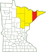
| Lake County | ||||||
| Northeast Minnesota | ||||||
Activities |
||
Hiking Trails |
||
No maintained trails |
||
Hunting |
||
All hunting and trapping. See Hunting and Trapping Regulations (MN DNR) for details. |
||
Ecology |
|||||||
Ecological Classification |
 |
||||||
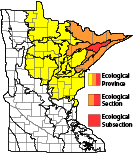
| Ecological Province | Laurentian Mixed Forest Province |
||||||
| Ecological Section | Northern Superior Uplands |
||||||
| Ecological Subsection | Laurentian Uplands |
||||||
| Land Type Association | Greenwood Lake Till Plain Seven Beavers Peatland |
||||||
Native Plant Communities* |
|||||||
Alder Swamp / Forested Peatland Complex Aspen - Birch Forest: Balsam Fir Subtype Beaver Wetland Complex Black Spruce Bog Black Spruce Bog: Semi-Treed Subtype Black Spruce Bog: Treed Subtype Forested Peatland / Upland Transition Complex Graminoid Bog: Typic Subtype Graminoid Poor Fen (Basin) Graminoid Poor Fen (Water Track): Featureless Water Track Subtype Graminoid Poor Fen (Water Track): Flark Subtype Graminoid Rich Fen (Water Track) Graminoid Rich Fen (Water Track): Featureless Water Track Subtype Graminoid Rich Fen (Water Track): Flark Subtype Low Shrub Bog Low Shrub Poor Fen Northern Mesic Mixed Forest Northern Mixed Cattail Marsh Northern Open Bog Northern Poor Conifer Swamp Northern Poor Fen Northern Rich Fen (Water Track) Northern Rich Tamarack Swamp (Water Track) Northern Rich Tamarack Swamp (Western Basin) Northern Wet-Mesic Boreal Hardwood-Conifer Forest Poor Black Spruce Swamp Poor Tamarack - Black Spruce Swamp Poor Tamarack - Black Spruce Swamp: Tamarack Subtype Rich Black Spruce Swamp (Basin) Rich Tamarack - (Alder) Swamp Shrub Rich Fen (Water Track) Upland White Cedar Forest White Cedar Swamp (Northeastern) White Pine - Red Pine Forest Willow - Dogwood Shrub Swamp Young Forest Complex |
|||||||
| * Source: The Minnesota Biological Survey, Minnesota Department of Natural Resources, Division of Ecological Resources | |||||||
Natural Features |
|||||||
|
|||||||
Boat Required
Sand Lake Peatland SNA is accessible only by canoe.

GPS recommended

A GPS unit and detailed map are recommended.
Visitor Photos |
|||||
Share your photo of this destination. |
|||||
| This button not working for you? Simply email us at info@MinnesotaSeasons.com. Attach one or more photos and, if you like, a caption. |
|||||
|
|||||
MinnesotaSeasons.com Photos |
|||||
|
|||||

Slideshows |
||
Visitor Videos |
|||
Share your video of this destination. |
|||
| This button not working for you? Simply email us at info@MinnesotaSeasons.com. Attach a video, a YouTube link, or a cloud storage link. |
|||
Other Videos |
|||
| Sand Lake Peatland Scientific and Natural Area Virtual Hike Minnesota Department of Natural Resources |
|||
About
Mar 25, 2022 Sand Lake Peatland SNA is part of a larger complex of public and private land of outstanding biodiversity. Four rivers emanate from this remote, relatively undisturbed landscape, including the St. Louis River, a major tributary to Lake Superior. The peatlands, bogs, and swamps found in this site help capture and store carbon that would otherwise contribute to climate change. Even though you may not visit this remote site in person, you can rest assured, knowing that it is permanently protected. mndnr.gov/snas/sna02010 |
|||
| Return to the Sand Lake Peatlands MinnesotaDNR |
|||

Created: Last Updated: © MinnesotaSeasons.com. All rights reserved. |
