![]()
![]()
![]()
![]()
Split Rock Lighthouse State Park
About • Location • Activities • Ecology
About |
Ownership |
|
Links |
Overview |
|
History |
|
Management |
|
Comments |
|
Location |
||||||||||||||||||||||||||||||
Size |
||||||||||||||||||||||||||||||
2,260 acres statutory, 2,103 owned |
||||||||||||||||||||||||||||||
Driving Directions |
||||||||||||||||||||||||||||||
|
||||||||||||||||||||||||||||||
Parking |
||||||||||||||||||||||||||||||
Visitor Center N47 12.062, W91 22.020 |
||||||||||||||||||||||||||||||
Hours |
||||||||||||||||||||||||||||||
Daily from 8 a.m. until 10 p.m. |
||||||||||||||||||||||||||||||
Fees |
||||||||||||||||||||||||||||||
Daily park permit: $7 Annual park permit: $35 |
||||||||||||||||||||||||||||||
Maps |
||||||||||||||||||||||||||||||

Activities |
||||||||||||||
Hiking Biking Mountain biking Horseback riding Picnicking Camping Backpacking Rock climbing and bouldering Swimming Boating Canoeing Birding Nature photography Geocaching Cross country skiing Skate-skiing Winter hiking Snowshoeing Snowmobiling |
||||||||||||||
Trails |
||||||||||||||
|
||||||||||||||
Hunting and Fishing |
||||||||||||||
Approximately 50 acres in the far northern part of the park is open to public hunting but closed trapping. See Hunting and Trapping Regulations (MN DNR) for details. In most cases, Minnesota residents do not need a permit to fish in Minnesota State Parks. |
Ecology |
|||||
Ecological Classification |
 |
||||
| Ecological Province | Laurentian Mixed Forest Province |
||||
| Ecological Section | Northern Superior Uplands |
||||
| Ecological Subsection | North Shore Highlands |
||||
| Land Type Association | Split Rock Till Plain |
||||
Native Plant Communities* |
|||||
Aspen - Birch Forest: Hardwood Subtype Bedrock Shrubland (Inland) Bedrock Shrubland (Lake Superior) Black Ash - Aspen - Balsam Poplar Swamp (Northeastern) Crystalline Bedrock Outcrop (Northern) Dry Felsic Cliff (Northern) Dry Open Talus (Northern) Exposed Mafic Cliff (Lake Superior) Gravel/Cobble Beach (Lake Superior) Lake Superior Rocky Shore Lowland White Cedar Forest (North Shore) Spruce - Fir Woodland (North Shore) Upland White Cedar Forest White Pine - Red Pine Forest Wet Mafic Cliff (Northern) Willow - Dogwood Shrub Swamp Young Forest Complex |
|||||
| * Source: The Minnesota Biological Survey, Minnesota Department of Natural Resources, Division of Ecological Resources | |||||
Natural Features |
|||||
|
|||||
Visitor Photos |
||
Share your photo of this destination. |
||
This button not working for you? |
||
Wayne Rasmussen |
||
 |
 |
|
MinnesotaSeasons.com Photos |
||
 |
 |
|
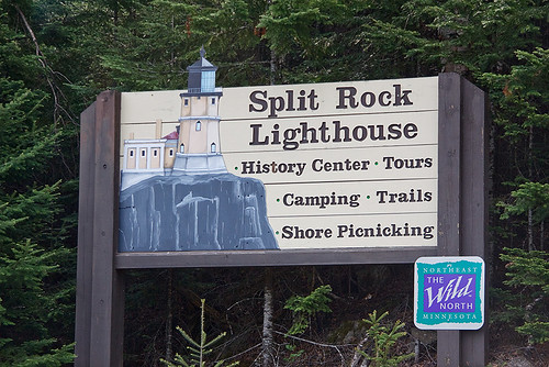
Park entrance |
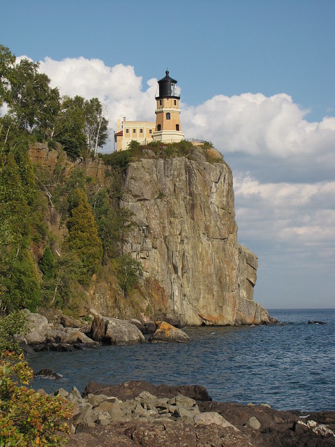
View from the lignthouse | |
 |
 |
|
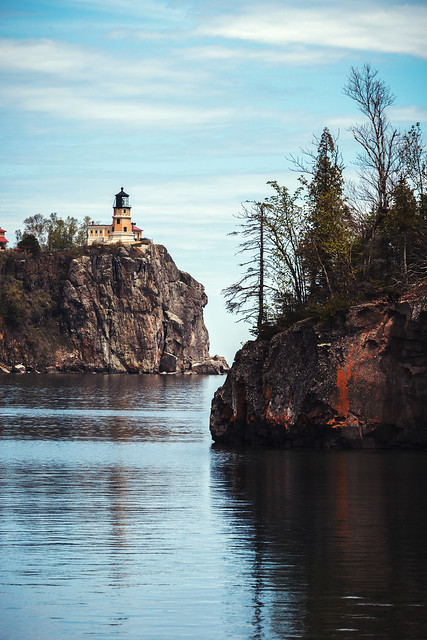
Split Rock Lighthouse |
||

Slideshows |
Split Rock Lighthouse |
|
Split Rock Lighthouse State Park |
|
Split Rock Lighthouse State Park |
|
About
No description |
Split Rock Lighthouse MN |
About
Published on Feb 13, 2014 I created this video with the YouTube Slideshow Creator |

Visitor Videos |
||
Share your video of this destination. |
||
This button not working for you? |
||
|
Other Videos |
||
TravelswithYoly |
About
hj5JIMEn3sw Split Rock Light Station was put into service on July 31, 1910 near the town of Two Harbors on the north shore of Lake Superior.It was built in response to a disastrous 1905 storm that sank or damaged 29 ships on western Lake Superior. During its first 20 years, the station was only accessible by boat so lighthouse keepers and families lived on-site for the Lake Superior shipping season and left for the winter months. In 1924 Hwy 61 was extended past the light station which made the site accessible by car. By the 1930s keepers and their families could live there year round and the light station had become a popular tourist attraction. The bivalve Fresnel lens was built in Paris, France by Barbier, Bernard & Turene. It was assembled prism by prism in the lighthouse's lantern room with a total weight of nearly 6.5 tons. The lens made one revolution every 20 seconds, floating on a thin layer of mercury. Gears driven by weights on cables turned the lens. Light for the beacon was provided by an incandescent kerosene vapor lamp. |
Brian Prom |
About
Published on Apr 15, 2012 A tour inside of the Split Rock Lighthouse in Two Harbors Minnesota. The Split Rock Lighthouse is on Lake Superior. The lighthouse is now non-operational, and is part of Split Rock Lighthouse State Park. This is a great place for camping and sight seeing. |
OpenRoadAdventures |
About
Uploaded on Mar 1, 2011 http://OpenRoadAdventures.biz - Explore the history of the Split Rock Lighthouse in Minnesota. Split Rock is located along the North Shore of Lake Superior near the town of Two Harbors. Split Rock Lighthouse is said to be the "most photographed lighthouse in the United States". Take the history tour and see why. Visit www.OpenRoadAdventures.biz for more on the Split Rock Lighthouse in Minnesota and to see our Minnesota Audio Tours. |

Visitor Sightings |
|
Share your sightings or comments about of this destination. |
|
This button not working for you? |
|
Birgitta Anderson |
||
Mammals |
||
| Franklin’s Ground Squirrel (Poliocitellus franklinii) | ||
MinnesotaSeasons.com Sightings |
Visits |
5/26/2011 |
Birds |
||||||||||||
|
||||||||||||
Minnesota Biodiversity Atlas Birds List eBird Field Checklist – Split Rock Lighthouse SP |
||||||||||||
Fishes |
||
Fungi and Lichens |
||
Insects and Arachnids |
||

Created: Last Updated: © MinnesotaSeasons.com. All rights reserved. |