![]()
![]()
![]()
![]()
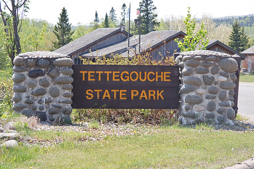
Tettegouche State Park
About • Location • Activities • Ecology
About |
Ownership |
|
Links |
Overview |
|
History |
|
Management |
|
Comments |
|
Location |
||||||||||||||||||||||||||||||
Size |
||||||||||||||||||||||||||||||
9,489 acres statutory, 9,009 owned |
||||||||||||||||||||||||||||||
Driving Directions |
||||||||||||||||||||||||||||||
|
||||||||||||||||||||||||||||||
Parking |
||||||||||||||||||||||||||||||
5702 Highway 61 N47 20.326, W91 11.812 |
||||||||||||||||||||||||||||||
Hours |
||||||||||||||||||||||||||||||
Daily from 8 a.m. until 10 p.m. |
||||||||||||||||||||||||||||||
Fees |
||||||||||||||||||||||||||||||
Daily park permit: $7 Annual park permit: $35 |
||||||||||||||||||||||||||||||
Maps |
||||||||||||||||||||||||||||||

Activities |
||||||||||||||||||
Hiking Biking Mountain biking Horseback riding Picnicking Camping Backpacking Rock climbing and bouldering Swimming Boating Canoeing Birding Nature photography Geocaching Cross country skiing Skate-skiing Winter hiking Snowshoeing Snowmobiling |
||||||||||||||||||
Trails |
||||||||||||||||||
|
||||||||||||||||||
Hunting and Fishing |
||||||||||||||||||
Much of the southern half of the park (approximately 3,700 acres) known as the Palisade Valley unit is open to public hunting and trapping. See Hunting and Trapping Regulations (MN DNR) for details. In most cases, Minnesota residents do not need a permit to fish in Minnesota State Parks. |
Ecology |
|||||
Ecological Classification |
 |
||||
| Ecological Province | Laurentian Mixed Forest Province |
||||
| Ecological Section | Northern Superior Uplands |
||||
| Ecological Subsection | North Shore Highlands |
||||
| Land Type Association | North Shore Till Plain Sawtooth Mountain Bedrock Complex |
||||
Native Plant Communities* |
|||||
Alder - (Maple - Loosestrife) Swamp Aspen - Birch Forest Beaver Wetland Complex Bedrock Shrubland (Lake Superior) Black Ash - Aspen - Balsam Poplar Swamp (Northeastern) Black Ash - Conifer Swamp (Northeastern) Crystalline Bedrock Outcrop (Northern) / Bedrock Shrubland (Inland) / Woodland Complex Dry Mafic Cliff (Northern) / Northern Talus Complex Exposed Felsic Cliff (Lake Superior) Exposed Mafic Cliff (Lake Superior) Gravel/Cobble Beach (Lake Superior) Lake Superior Rocky Shore / Bedrock Shrubland / Bedrock Outcrop Complex Lowland White Cedar Forest (North Shore) Mesic Mafic Cliff (Northern) Mesic Mafic Cliff (Northern) / Northern Talus Complex Northern Poor Fen Complex Northern Talus Complex Paper Birch - Sugar Maple Forest (North Shore) Red Oak - Sugar Maple - Basswood - (Bluebead Lily) Forest Red Pine - White Pine Woodland (Canadian Shield) Rich Black Spruce Swamp (Basin) Sand / Gravel / Cobble / Bedrock / Boulder Shore (River) Complex Sedge Meadow Spruce - Fir Woodland (North Shore) Sugar Maple - Basswood - (Bluebead Lily) Forest Sugar Maple Forest (North Shore) Upland White Cedar Forest White Cedar - Yellow Birch Forest Willow - Dogwood Shrub Swamp |
|||||
| * Source: The Minnesota Biological Survey, Minnesota Department of Natural Resources, Division of Ecological Resources | |||||
Natural Features |
|||||
|
|||||
Visitor Photos |
||
Share your photo of this destination. |
||
This button not working for you? |
||
Wayne Rasmussen |
||
Probably one of the most popular State Parks in Minnesota with uncounted photo keepsakes taken by more than half of the population of the state. We visit this park on every trip to the North Shore. |
 |
|
 |
 |
|
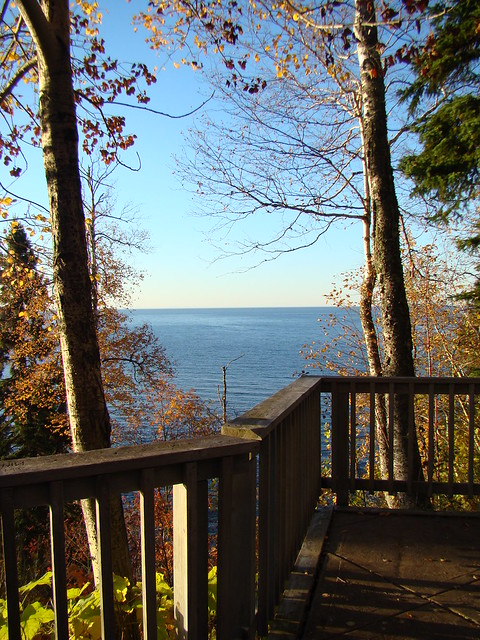
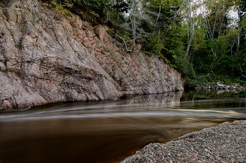
MinnesotaSeasons.com Photos |
||
 |
 |
|
Park entrance |
Park office | |
 |
||
Baptism River |
||

Slideshows |
Tettegouche State Park |
|
Tettegouche State Park |

|
Tettegouche State Park |
|
About
Baptism River |
Tettegouche State Park |
|
About
Tettegouche State Park |
Tettegouche State Park, Minnesota |
About
Published on Oct 30, 2013 Favorite Sites: 1, 2, 4, 9, 12, 17, 26 |
Tettagoughe State park |
About
Published on Feb 11, 2014 I created this video with the YouTube Slideshow Creator |

Visitor Videos |
||
Share your video of this destination. |
||
This button not working for you? |
||
|
Other Videos |
||
| Tettegouche State Park Cameron Stone |
About
Uploaded on Feb 20, 2011 Camped at Tettegouche on my bicycle trip up the north shore in 2010. Great campgound! Of all the campgrounds I camped in along the north shore, this one is the most wooded and private! Also this one has the most wildlife! |
| Tettegouche State Park Avery Nelson |
About
Published on Jul 16, 2012 Camping trip to Tettegouche State Park in June 2012 |

Visitor Sightings |
|
Share your sightings or comments about of this destination. |
|
This button not working for you? |
|
Margot Avey |
||
Fungi and Lichens |
||
| Coral Tooth Fungus (Hericium coralloides) |  |
|
MinnesotaSeasons.com Sightings |
Visits |
5/26/2011 |
Amphibians |
||
Birds |
||||||||||
|
||||||||||
Minnesota Biodiversity Atlas Birds List eBird Field Checklist (Complete) |
||||||||||
Fishes |
||||||||
|
||||||||
Fungi and Lichens |
||||||||
|
||||||||
Insects and Arachnids |
||
Plants |
||||||||||||
|
||||||||||||
Minnesota Biodiversity Atlas and Minnesota Biological Survey Vegetation Releves Plant List |
||||||||||||
Plants frequently found in: Aspen - Birch Forest: Balsam Fir Subtype FDn43b1 Bedrock Shrubland (Lake Superior) ROn23b Black Ash - Aspen - Balsam Poplar Swamp (Northeastern) WFn55a Black Ash - Conifer Swamp (Northeastern) WFn64a Exposed Felsic Cliff (Lake Superior) CTu22b Exposed Mafic Cliff (Lake Superior) CTu22a Gravel/Cobble Beach (Lake Superior) LKu32e Lowland White Cedar Forest (North Shore) WFn53a Mesic Mafic Cliff (Northern) CTn32a Paper Birch - Sugar Maple Forest (North Shore) MHn45a Red Oak - Sugar Maple - Basswood - (Bluebead Lily) Forest MHn35b Red Pine - White Pine Woodland (Canadian Shield) FDn32a Rich Black Spruce Swamp (Basin) FPn62a Spruce - Fir Woodland (North Shore) FDn32e Sugar Maple - Basswood - (Bluebead Lily) Forest MHn47a Sugar Maple Forest (North Shore) MHn45c Upland White Cedar Forest FDn43c |
||||||||||||
Reptiles |
||

Created: Last Updated: © MinnesotaSeasons.com. All rights reserved. |