![]()
![]()
![]()
![]()
Savage Fen SNA
About • Location • Activities • Ecology
About |
||
Ownership |
||
|
||
Links |
||
Overview |
||
|
||
History |
||
Savage Fen SNA was designated on 11/16/1989. In 2011, the Minnesota DNR acquired a 68-acre parcel that became the Southeast Unit of Savage Fen SNA. On June 12, 2013, the Minnesota DNR and the U.S. Fish and Wildlife Service completed a land exchange that included four tracts of land, totalling 188.15 acres, adjacent to the SNA. The acquisition connected the Northeast and Southeast Units and greatly expanded the West Unit. |
||
Management |
||
On the East Unit, two small areas were cleared in 2014, one by the designated parking spot, the other in front of the wood routed sign. In the spring of 2015 these were covered with jute fabric and planted with cereal rye for soil stabilization. In 2016 the rye was gone and native species returned. A 25-acre area at the southeast corner of the West Unit has been the focus of recent management activity. The West Unit has not been burned since 1970. In the winter of 2015-16 woody species were selectively cut down and a fire break was cleared. The smaller stems, shrubs, were left where they were cut. The larger stems, trees, were piled for later removal. Buckthorn was cut and treated with herbicide. Seeds of native grasses and forbs were collected. All in preparation for a prescribed burn in the spring of 2016. That burn has been postponed indefinitely. In the fall of 2016, removal of native and non-native Phragmites began in two small selected areas. That work continued in the fall of 2017. In the winter of 2017-18, woody species were cut and removed from the westernmost portion of the West Unit. The trees and shrubs that had been cut and piled in 2015-16 were also removed. |
||
Comments |
||
|
||
Location |
||||
Maps |
||||
Printable Map(s) with GPS coordinates |
||||
Complete |
||||
 |
||||
West Unit |
East Unit | |||
 |
 |
|||
Size |
||||
East Unit: 152 acres West Unit: 136 acres |
||||
Parking |
||||
East Unit N44 46.458, W93 21.130 West Unit N44 46.308, W93 22.357 |
||||
Driving Directions |
 |
|||||
| Scott County | ||||||
| Metro Area | ||||||
Activities |
||
Hiking Trails |
||
Although there are no maintained trails, there are several trails on the East Unit. A utility road leads from the parking area south into the SNA then west to Quentin Ave. S. The roadbed is raised and should be accessible even during spring flooding. Near the east end of this road a forest road (former USF&WS administrative road) leads south into the forest then west along the base of the bluff. Where the administrative road turns west a well worn trail continues straight up the bluff. This trail and a few connecting trails lead west and south to a housing development. The land acquired from the U.S. Fish and Wildlife Service in 2013 came with the stipulation that a bike trail be constructed through the East Unit. A potential trail was surveyed in 2014. The route follows the old forest road along the base of the bluff. It was subsequently determined that the proposed route could not be made in compliance with the Americans with Disabilities Act of 1990. |
||
Hunting |
||
Archery only. See Hunting and Trapping Regulations (MN DNR) for details. |
||
Ecology |
|||||||
Ecological Classification |
 |
||||||
| Ecological Province | Eastern Broadleaf Forest Province |
||||||
| Ecological Section | Minnesota & NE Iowa Morainal |
||||||
| Ecological Subsection | Big Woods |
||||||
| Land Type Association | Elko Moraine Le Sueur Alluvial Plain |
||||||
Native Plant Communities* |
|||||||
Calcareous Fen (Southeastern) Elm - Basswood - Black Ash - (Hackberry) Forest Mesic Prairie (Southern) Seepage Meadow/Carr Sugar Maple - Basswood - (Bitternut Hickory) Forest |
|||||||
| * Source: The Minnesota Biological Survey, Minnesota Department of Natural Resources, Division of Ecological Resources | |||||||
Natural Features |
|||||||
|
|||||||
Waterproof footwear recommended
![]()
The seepage meadow and fen areas may have some standing water year round. Narrow intermittent and perennial streams are completely hidden from view by leaning grasses and sedges. Waterproof footwear is recommended.
Visitor Photos |
|||||
Share your photo of this destination. |
|||||
| This button not working for you? Simply email us at info@MinnesotaSeasons.com. Attach one or more photos and, if you like, a caption. |
|||||
|
|||||
MinnesotaSeasons.com Photos |
|||||
East Unit |
|||||
Parking |
|||||
 |
 |
||||
Wood Routed Sign |
|||||
 |
|||||
Interpretive Sign |
|||||
 |
|||||
Utility Road |
|||||
 |
 |
||||
Old Forest Road |
|||||
 |
|||||
Chain Link Fence |
|||||
 |
 |
||||
Cinderblock Wall |
|||||
 |
 |
||||
Duck Pond |
|||||
 |
 |
||||
Pond |
|||||
 |
 |
||||
Spring |
|||||
 |
 |
||||
Credit River |
|||||
 |
 |
||||
Elm - Basswood - Black Ash - (Hackberry) Forest |
|||||
 |
 |
||||
Seepage Meadow/Carr |
|||||
 |
 |
||||
Sugar Maple - Basswood - (Bitternut Hickory) Forest |
|||||
 |
 |
||||
West Unit |
|||||
Parking |
|||||
 |
 |
||||
Entrance |
|||||
 |
 |
||||
Wood Routed Sign |
|||||
 |
 |
||||
Interpretive Sign |
|||||
 |
 |
||||
Buried Pipeline |
|||||
 |
|||||
Glacial Erratic |
|||||
 |
 |
||||
 |
|||||
Perennial Stream This stream has sunk 16" to 20" into the peat. Protected from cold tempreatures, it remains unfrozen and flowing year round. |
 |
||||
East Pond |
|||||
 |
 |
||||
Frog Pond This was once a beaver pond. Beavers were actively hunted here and eventually extirpated. Only frogs live here now. |
 |
||||
 |
|||||
Seepage Meadow/Carr |
|||||
 |
 |
||||
Calcareous Fen (Southeastern) |
|||||
 |
|||||
 |
 |
||||
 |
|||||
Sugar Maple - Basswood - (Bitternut Hickory) Forest |
|||||
 |
|||||
Woody Species Removal, Winter 2015-16 |
|||||
 |
 |
||||
Habitat Restoration |
|||||
Before restoration, October 2015 |
 |
||||
| Restoration begins by removing encroaching shrubs and trees, April 2018 |  |
||||
 |
 |
||||
| May 2018 |  |
||||
Sunrise on Savage Fen |
|||||
 |
 |
||||
Pussy Willows Flowering in April |
|||||
 |
|||||

Slideshows |
||
| Savage Fen SNA Mikes Orchids |
||
|
||
About
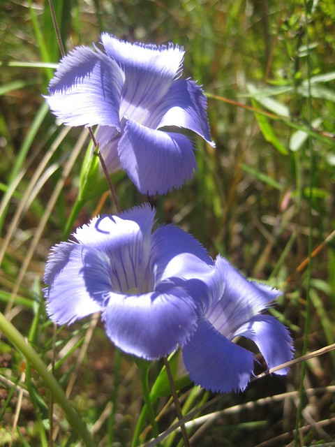
This is a visit to Savage Fen Scientific and Natural Area in Savage Minnesota. Savage Fen is located below the bluffs along the Minnesota River on the south side. It is a unique example of one of Minnesota's rarest plant and animal communities. It is a calcareous fen, meaning that it is a wetland adapted to growing in the highly alkaline water seeping out of the bluffs. The wetland acts like a sponge, absorbing this water and holding it there supporting a unique assembly of plants and animals. See more here: www.dnr.state.mn.us/snas/sna00999/index.html |
||

Visitor Videos |
|||
Share your video of this destination. |
|||
| This button not working for you? Simply email us at info@MinnesotaSeasons.com. Attach a video, a YouTube link, or a cloud storage link. |
|||
Other Videos |
|||
| 10-28-17 Savage Fen Scientific and Natural Area, MN Blondie Customer |
|||
About
Jun 2, 2018 |
|||


")
")


")


")


")


_02.jpg "mountain death camas (var. elegans)")


_01.jpg "prairie fleabane (var. strigosus)")


Dragonfly Survey
A Status Survey for Special Concern and Endangered Dragonflies of Minnesota was conducted in 1998. Savage Fen was evaluated as potential habitat for Hine’s Emerald (Somatochlora hineana), a federally endangered dragonfly. It was determined that the site is probably too fragmented to support populations of Hine’s Emerald. Only two species were reported from Savage Fen in the survey, Halloween pennant (Celithemis eponina) and white-faced meadowhawk (Sympetrum obtrusum).
Created: Last Updated: © MinnesotaSeasons.com. All rights reserved. |